

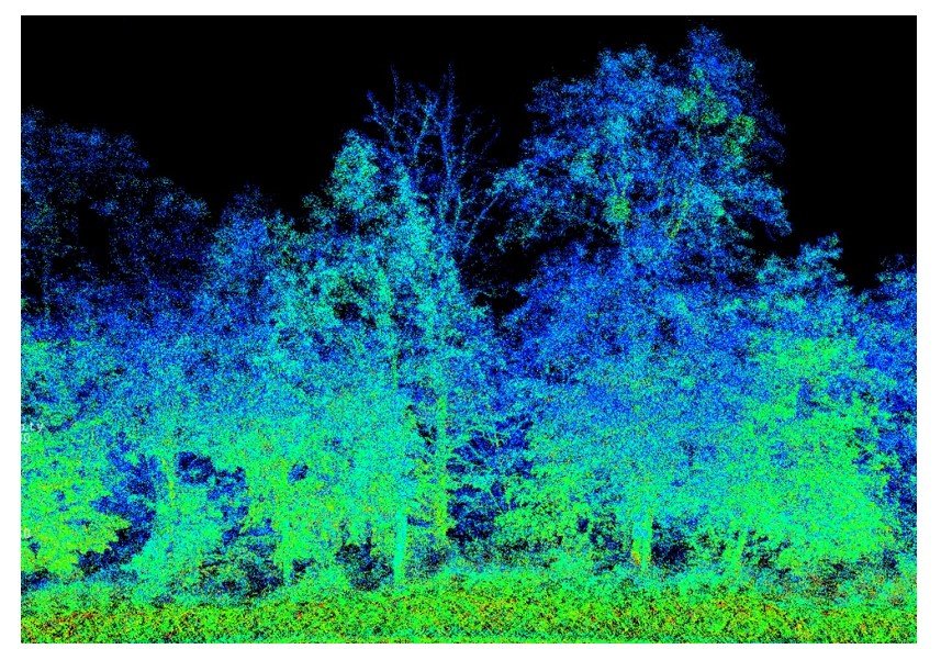
LiDAR—an acronym for Light Detection and Ranging—has revolutionized spatial data collection over the past two decades by enabling surveyors to capture millions of precise 3D coordinate measurements every single second. Unlike passive optical cameras that rely on ambient sunlight, LiDAR is an active remote sensing technology that illuminates physical targets with rapid pulses of laser light and measures the reflected return signals. Whether mounted on a stationary tripod, a moving highway vehicle, a low-flying UAV, or a manned aircraft, LiDAR surveying produces dense, millimeter-to-centimeter-accurate 3D “point clouds” that replicate complex physical environments in extraordinary geometric detail.
How LiDAR Measures Distance and Position
At its core, a topographic LiDAR sensor combines a high-frequency pulsed laser emitter, an optical scanner (such as a rotating polygonal mirror or oscillating prism), and an ultra-sensitive photodetector. For each emitted pulse—modern airborne and mobile sensors fire between 300,000 and 2,000,000 pulses per second—the system determines range ( ) using either Time-of-Flight (ToF) or Phase-Shift measurement:
where is the speed of light and is the elapsed round-trip travel time of the laser pulse.
When mounted on a moving platform such as an aircraft, survey van, or drone, raw laser range and scan angle alone are insufficient; the system must know the sensor’s exact 3D position and spatial orientation at the instant each pulse fires. An integrated Position and Orientation System (POS) fuses high-rate GNSS positioning with a tactical-grade Inertial Measurement Unit (IMU) to continuously resolve sensor trajectory ( ) and attitude (roll, pitch, and heading), transforming billions of raw laser ranges into a unified, georeferenced 3D point cloud.
The Canopy-Penetration Advantage: Multiple Returns
One of LiDAR’s defining technological advantages over traditional photogrammetry is its ability to penetrate vegetation canopies and opaque obscurants. A single emitted laser pulse has a finite beam footprint—typically a few centimeters to tens of centimeters wide depending on flying altitude. When that pulse strikes a forested tree canopy, part of the energy reflects off the upper leaves and branches (generating a first return), additional energy reflects off intermediate foliage layers (intermediate returns), and the remaining photons pass through tiny gaps in the canopy to strike the bare ground beneath (last return).
By classifying points according to return number, intensity values, and geometric filtering algorithms, surveyors strip away trees, shrubs, and temporary structures to extract a remarkably accurate bare-earth Digital Terrain Model (DTM) even beneath dense tropical rainforests or heavily wooded mountain slopes. This reveals hidden archaeological ruins, subtle geological fault scarps, and intricate drainage networks completely invisible to aerial photographs.
The Three Primary LiDAR Deployment Platforms
- Terrestrial Laser Scanning (TLS): Tripod-mounted static scanners rotate 360 degrees horizontally and nearly 300 degrees vertically, capturing millimeter-accurate point clouds from individual setup positions. TLS is the gold standard for complex industrial plants, refinery piping retrofits, historic monument preservation, bridge girder clearance checks, and detailed interior architectural floorplans.
- Mobile LiDAR Mapping Systems (MLS): Mounted on cars, pickup trucks, rail inspection carts, or backpacks (using Simultaneous Localization and Mapping, or SLAM, algorithms indoors), mobile scanners capture highway corridors, urban streetscapes, overhead utility lines, and railway tunnels at normal traffic speeds—eliminating dangerous lane closures and keeping field crews safe from traffic hazards.
- Airborne Laser Scanning (ALS): Deployed from fixed-wing aircraft, helicopters, or heavy-lift UAVs, airborne LiDAR maps expansive corridors, floodplains, coastal cliffs, transmission line right-of-ways, and forestry inventories rapidly and uniformly across vast areas.
Point Cloud Processing and Downstream Workflows
Raw point clouds are massive datasets often containing billions of individual points enriched with laser return intensity values and RGB color attributes mapped from co-aligned digital cameras. Surveying specialists process these massive clouds through several rigorous stages:
- Point Cloud Registration: Aligning overlapping scans via physical targets or cloud-to-cloud Iterative Closest Point (ICP) algorithms into a seamless project coordinate system.
- Filtering and Noise Removal: Eliminating atmospheric interference, birds, passing vehicles, and construction dust.
- Classification: Separating ground points from vegetation, buildings, and power lines using automated machine-learning routines followed by manual quality control.
From a single LiDAR scan campaign, engineers extract multiple high-value deliverables:
- Scan-to-BIM Models: Converting point clouds of existing factories, hospitals, or historic buildings into intelligent parametric Revit or CAD models for clash-free renovation design.
- Vegetation Encroachment Analysis: Electric utilities scan thousands of kilometers of high-voltage transmission lines to identify individual tree branches growing too close to sagging conductors, preventing wildfires and power outages.
- Coastal Erosion and Landslide Monitoring: Comparing sequential LiDAR scans collected months apart reveals exact volumetric changes along eroding sea cliffs, riverbanks, and unstable rock slopes.
By combining speed, active illumination independent of shadow, vegetation penetration, and dense 3D geometric fidelity, LiDAR surveying has become an indispensable cornerstone of modern geospatial engineering.